By Chris Carpenter
Sarasota sits on one of the most photogenic stretches of Florida's Gulf Coast, and much of what makes living here rewarding is how much of it you can experience simply by getting in the car and driving. The barrier islands, bay crossings, inland state parks, and old Florida back roads are all accessible within a short drive from downtown.
I work with buyers and sellers across Sarasota constantly, and when people want to understand what daily life here looks and feels like, I point them toward the roads first. These four routes are the ones I return to most.
Key Takeaways
- State Road 789 is the definitive Sarasota scenic drive: A 17.5-mile coastal route from downtown through Bird Key, St. Armands Circle, Lido Key, and up Gulf of Mexico Drive on Longboat Key, offering continuous Gulf and bay views.
- Casey Key Road is the most secluded of the Sarasota scenic routes: An eight-mile narrow barrier island between Sarasota and Venice with Gulf-front architecture, limited traffic, and dual water views on both sides.
- Myakka River State Park's 7-mile scenic drive is the most dramatic inland option: Its interior drive winds along Upper Myakka Lake through wetlands, prairies, and oak hammocks teeming with wildlife.
- The John Ringling Causeway is the most iconic stretch of road in Sarasota: A 65-foot bridge linking downtown to St. Armands Key with bay views in every direction and one of the best sunset vantage points in the area.
State Road 789: The Gulf Coast Drive
State Road 789 is the backbone of Sarasota sightseeing by car. This 17.5-mile coastal road runs north from the John Ringling Causeway through Bird Key, St. Armands Key, Lido Key, and up Gulf of Mexico Drive on Longboat Key to Anna Maria Island.
- The causeway approach: The route opens with a 65-foot rise over Sarasota Bay, with open water views in both directions and fishing boats below near Marina Jack on the south side.
- Bird Key and St. Armands Circle: A small residential island connects to St. Armands Key and the shopping and dining district of St. Armands Circle. Lido Key Beach lies just beyond.
- Gulf of Mexico Drive on Longboat Key: Two lanes, beachfront homes, golf courses, and resort properties with periodic glimpses of white sand and aqua water.
The Visit Sarasota County road trip guide describes it as the kind of highway you want to be stuck on in slow traffic.
Keep Going North: The Bradenton Beach Scenic Highway
SR 789 doesn't stop at the county line. After crossing Longboat Pass onto Anna Maria Island, the last stretch becomes the Bradenton Beach Scenic Highway, a state-designated scenic highway built for walking and biking as much as driving. It's an easy way to turn the Gulf Coast drive into a half day.
SR 789 at a glance | Details |
|---|
Full length | About 17.6 miles, from US 41 in downtown Sarasota to SR 64 in Holmes Beach |
Drawbridges | New Pass Bridge (Lido Key to Longboat Key) and Longboat Pass Bridge (Longboat Key to Anna Maria Island) are both drawbridges, so allow for an occasional opening |
Scenic highway segment | About 2.8 miles of Gulf Drive in Bradenton Beach, designated a Florida Scenic Highway on April 17, 2001 |
Easy stop | Ken Thompson Park on City Island, home to Mote Aquarium, has bayfront views and easy parking just off the main road |
Casey Key Road: The Quiet Barrier Island
Casey Key is an eight-mile narrow barrier island between Sarasota and Venice. Its only road is low-speed, low-traffic, and largely residential, making it one of the most genuinely secluded Sarasota scenic routes within easy reach of the city.
- The architecture: Mid-century modern Gulf-front homes and larger estates line a strip so narrow the Gulf is visible on one side and the Intracoastal Waterway on the other.
- The entry: Access via Blackburn Point Road from US 41 takes you over two swing bridges past boat ramps where kayakers put in.
- The pace: The speed limit in many stretches is 15 mph, with sidewalk sections alongside for pedestrians.
Casey Key surprises buyers when they first encounter it. The seclusion, architecture, and dual water exposure make it one of the most distinctive stretches in the area.
Extend the Casey Key Drive South
Casey Key Road makes a natural loop. Come in from the north over the historic Blackburn Point Bridge, drive south along the island, and keep going to Nokomis Beach or all the way to the North Jetty at Venice. The island's second connection to the mainland, the Albee Road bridge, brings you back to US 41.
The Blackburn Point Bridge
A one-lane steel truss swing bridge that opened in December 1926 and is listed on the National Register of Historic Places. It's the only swing bridge left in Sarasota County, and the county has been studying whether to repair or replace it, so check for closures before you go.
Stops along the loop
Nokomis Beach is a natural stopping point on the south end of the island, and the North Jetty at Venice makes a good final destination. Both work well for a walk on the sand before heading home on US 41.
Sources: Sarasota County, via WWSB and Bay News 9 coverage of the bridge study (2026); Sarasota Magazine; Visit Sarasota County (accessed November 2026).
Thinking about living near this drive? See Casey Key homes for sale or our Nokomis neighborhood guide.
Myakka River State Park: The Inland Scenic Drive
Myakka River State Park, via State Road 72 about 17 miles east of downtown, offers a completely different landscape from the coast. The park spans 58 square miles and protects the Myakka River, Florida's only state-designated Wild and Scenic River.
- The seven-mile scenic drive: The road winds along Upper Myakka Lake through wetlands, prairies, and oak hammocks. Alligators, wading birds, deer, and sandhill cranes are consistent sightings.
- The Canopy Walkway: A treetop nature walk 35 feet off the ground.
- The approach on SR-72: The drive crosses the Myakka River through open pastoral land. The transition from coastal Sarasota to this interior landscape takes about 20 minutes.
Myakka is one of Florida's oldest state parks, with CCC-built facilities still in use today. I regularly point buyers toward this park.
Know Before You Go: Myakka River State Park
A few practical details make the Myakka drive easier, especially if you're bringing out-of-town guests the way I often do. The Myakka is Florida's first state-designated wild and scenic river, and the park keeps posting updates on closures, so check before you go.
What to know | Details |
|---|
Hours | 8 a.m. to sunset, 365 days a year. The North Gate opens only on weekends and state holidays, 8 a.m. to 5 p.m. |
Entrance fee | $6 per vehicle |
Scenic drive and trails | The 7-mile park drive runs along Upper Myakka Lake, with more than 39 miles of hiking trails |
Canopy Walkway | Suspended 25 feet above the ground, with a 74-foot observation tower; no extra fee, but more than 100 stairs. The tower and bird walk were closed for maintenance as of May 2026, so check the park's alerts. |
Boat ramp | Temporarily closed to trailered boats due to low water as of May 2026 |
The John Ringling Causeway: The Classic Sarasota Scenic Route
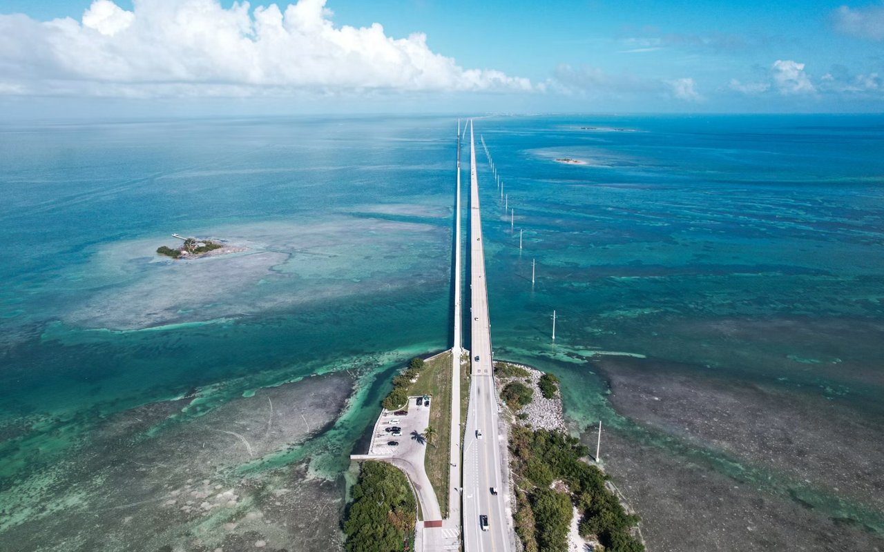
The John Ringling Causeway is barely more than a mile across Sarasota Bay, but it is the most iconic stretch of road in the city. The current 65-foot-high bridge opened in 2003 and is named for circus magnate John Ringling, who built the original causeway in 1926.
- The bay panorama: Crossing in either direction gives unobstructed views of Sarasota Bay, with the downtown skyline east and barrier islands to the west. Dolphins are frequently spotted below.
- The pedestrian path: A dedicated path runs the full length of the causeway, making a three-mile round-trip walk a popular resident activity.
- What it connects to: The island side opens directly to St. Armands Circle. Just north of the mainland end sits The Ringling, John Ringling's historic estate.
The causeway is the drive I take with out-of-town guests their first evening here.
FAQs
What is the best time of day for Sarasota scenic drives?
Early morning and the hour before sunset are the best windows. Morning light on the bay is clear and calm with minimal traffic on SR-789 and the causeway. The hour before sunset is worth planning around on the John Ringling Causeway and Casey Key, where western exposure delivers Gulf Coast light at its most photogenic.
Which scenic route near Sarasota is best for wildlife viewing?
For Sarasota sightseeing that combines wildlife and scenery, Myakka River State Park's 7-mile interior drive is the standout. Alligators, wading birds, deer, and sandhill cranes are regularly visible from the road, and the Canopy Walkway adds a treetop vantage point. Along the coastal routes, dolphin sightings from the John Ringling Causeway are common year-round.
Are these routes accessible to cyclists and pedestrians?
The John Ringling Causeway has a dedicated path running its full length. Casey Key Road has sidewalk sections used by pedestrians. SR-789 through Longboat Key has coastal trail access from various pull-offs. Myakka River State Park permits cycling on interior roads and offers bicycle rentals through the Myakka Outpost.
Contact Chris Carpenter Today
I have spent years helping buyers find homes in and around Sarasota, and part of that work is helping them understand what life here looks like. The drives and barrier island loops are what buyers discover after they move here and tell me they wish they had known earlier.
If you are considering Sarasota or want a specific picture of what different parts of the area look and feel like, reach out to me,
Chris Carpenter.
Sarasota's Scenic Drives at a Glance
Here are all four routes side by side, plus the extensions above. Each one runs past a different kind of neighborhood, which is part of why I use them to help buyers get oriented.
Route | Length | Bridges to know | Best for |
|---|
State Road 789 | About 17.6 miles | Ringling Causeway, New Pass and Longboat Pass bridges | Gulf views, St. Armands and Longboat Key |
Casey Key Road | About 8-mile island | Blackburn Point swing bridge (north), Albee Road bridge (south) | Quiet beachfront and a loop to Venice |
Myakka River State Park | 7-mile park drive | None inside the park | Wildlife and Old Florida landscape |
John Ringling Causeway | Just over a mile | A high fixed bridge with a pedestrian path | Bay views and sunset |
Bradenton Beach Scenic Highway | About 2.8 miles | Longboat Pass Bridge on the way in | A walkable, bikeable add-on to SR 789 |
Sources: Florida Department of Transportation; Florida State Parks; Visit Sarasota County; U.S. Coast Guard drawbridge regulations (33 CFR 117.287) (accessed November 2026).
If one of these drives already feels like home, I can show you the neighborhoods along it and current Sarasota homes for sale.
More ways to explore Sarasota
More questions about Sarasota scenic drives
How long is State Road 789?
About 17.6 miles, from US 41 in downtown Sarasota over the John Ringling Causeway, through Lido Key and Longboat Key, to SR 64 in Holmes Beach on Anna Maria Island.
Do Sarasota's bridges open for boats?
Some do. The John Ringling Causeway is a high fixed bridge, but the New Pass and Longboat Pass bridges on SR 789 are drawbridges. The Siesta Drive and Stickney Point bridges to Siesta Key open on a set daytime schedule under Coast Guard rules, and the Blackburn Point swing bridge to Casey Key opens for boat traffic too.
How much does it cost to drive into Myakka River State Park?
$6 per vehicle. The park is open from 8 a.m. to sunset every day of the year.
Is the Myakka Canopy Walkway open?
The park closed the canopy tower and bird walk for maintenance in May 2026. Check Florida State Parks' alerts for Myakka before you plan around it.
What is the Blackburn Point Bridge?
The one-lane swing bridge on Blackburn Point Road that connects the north end of Casey Key to the mainland. It opened in 1926, is on the National Register of Historic Places, and is the only swing bridge left in Sarasota County.
Which Sarasota neighborhoods sit along these drives?
Lido Key and Longboat Key line SR 789, Casey Key and Nokomis line the southern loop, and Lakewood Ranch is our inland market east of I-75. Browse
Sarasota homes for sale or ask me about a specific route.
Sources: Florida Department of Transportation; Florida State Parks; U.S. Coast Guard (33 CFR 117.287); Sarasota Magazine (accessed November 2026).
Find a home along your favorite drive
From Longboat Key to Casey Key to the ranch land east of town, I can show you what's for sale and what nearby homes have sold for.